Complete profile
100
Kategorie
Adresse
ul. Ornecka
14-520 Pieniężno
Poland
Früherer Straßenname
Wormditter Str., Ort: Mehlsack
Koordinate
54.230679265746, 20.126153104753
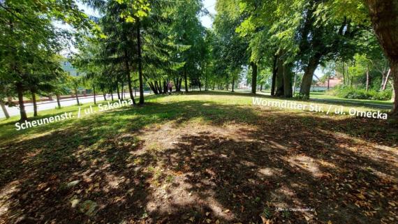
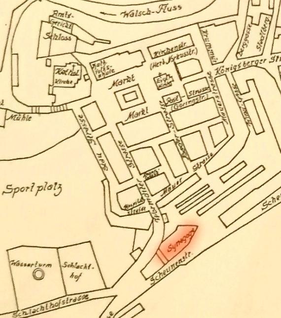
The small brick synagogue was built in 1860 in what was then Wormditter Street. On the occasion of the opening, the "Ermländische Aussteuerverein" was founded by those present to support poor Jewish girls. After the turn of the century, the small community could no longer afford a rabbi. The cult officials changed frequently. In 1938 the synagogue was sold to the local Baptist congregation. Nevertheless, during the Reichspogromnacht there was devastation inside the building. During the fighting in the spring of 1945, the building was destroyed, and the remains were later leveled. At present, the presumed site of the former synagogue is not built on.
Ereignisse
Beschreibung
Synagogue in Mehlsack (1885 mention of the 25th anniversary)
Ereignis
Datum Von
1860-01-01
Datum bis
1860-12-31
Datierung
1860
Epoche universalgeschichtlich
Beschreibung
to the Babitist Free Church
Ereignis
Datum Von
1938-01-01
Datum bis
1938-12-31
Datierung
1938
Epoche universalgeschichtlich
Beschreibung
Building is demolished inside during Pogrom Night.
Ereignis
Datum Von
1938-11-09
Datum bis
1938-11-09
Datierung
09.11.1938
Epoche universalgeschichtlich
Beschreibung
Conquest of the village by Russian troops
Ereignis
Datum Von
1945-01-01
Datum bis
1945-12-31
Datierung
1945
Epoche universalgeschichtlich
Medien
Standort der Synagoge von Mehlsack

Aufnahmedatum
18.08.2022
Fotografiert von
Ruth Leiserowitz
Leiserowitz
Bildquelle (Woher stammt das Bild)
Juden in Ostpreussen e.V.
Breite
1024
Höhe
577
Lizenz
CC BY-SA 4.0
Beschreibung
The location of the destroyed Mehlsack synagogue between Wormditter Str. and Scheunenstr. or today between ul. Ornecka and ul. Szkolna
Lageplan der Synagoge in der Stadt Mehlsack

Aufnahmedatum
18.08.2022
Fotografiert von
Michael Leiserowitz
Leiserowitz
Bildquelle (Woher stammt das Bild)
Barran, Fritz: Städte-Atlas Ostpreussen, Leer 1992, S. 46
Breite
614
Höhe
694
Lizenz
CC BY-SA 4.0
Beschreibung
Detail from a drawn map of the town of Mehlsack before the destruction in World War II and the post-war period.
Weiterführender Link
Literatur
Brüll, Dr. Adolf, Populär-wissenschaftliche Monatsblätter zur Belehrung über das Judenthum für Gebildete aller Confessionen Heft 5 (1.5.1885) S. 105
Fleischer Roland, „Das verachtete Volk der Juden“, Baptisten, die Pogromnacht 1938 und das Verhältnis zum Judentum, 2008 S. 210 Quelle Kurzbericht Bundeshaus, An die Mitglieder der BL, Berlin 24.11.1938
Redaktionell überprüft
Aus
Leichte Sprache
Aus
Partner Term
Add new comment