Complete profile
100
Kategorie
Adresse

Tonweg
37249 Hebenshausen
Germany

Koordinate
51.400303162225, 9.9076829189644

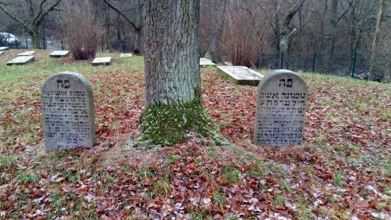
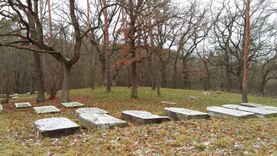
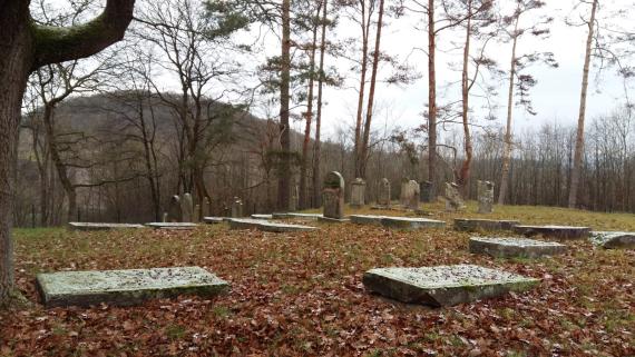
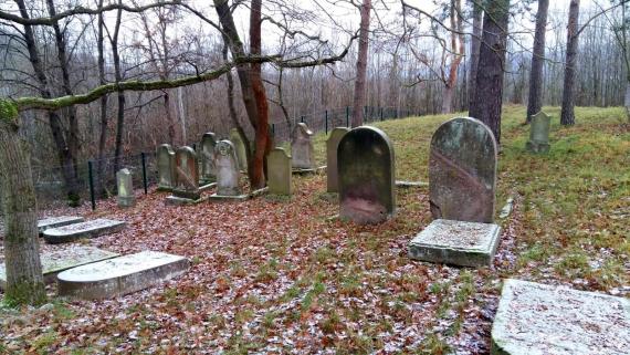
The Jewish cemetery of Hebenshausen is located two kilometers north of the village on a small hill at the edge of a small village. It can be reached by a tarred dirt road at the edge of the village or by a small access road of the B27 in direction Göttingen shortly before the exit Marzhausen. The cemetery was established at the beginning of the 18th century to provide the growing Jewish community with a local burial place. Previously, burials had taken place in the Jewish cemetery in Witzenhausen. The Jewish community in Hebenshausen also included the few Jews from the nearby village of Marzhausen. The cemetery comprises between 200 and 250 graves. Today there are about 76 gravestones from the period of 1736 to 1922, lying or standing upright irregularly distributed on the site. Since the number of Jewish parishioners decreased at the beginning of the 20th century (according to the Landesgeschichtliches Informationssystem Hessen-1861: 104; 1905: 29; 1925: 6; 1932/33: 6), the cemetery was no longer in use from the beginning of the 1920s. The last Jewish village member Abraham Hesse (1867-1956) was buried in the church cemetery in the village center after his death in 1956.

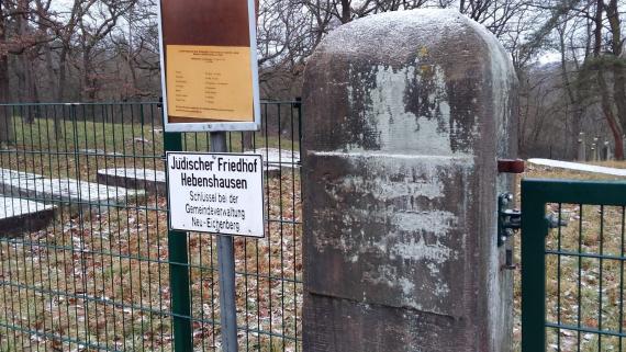
Many of the gravestone inscriptions were written in Hebräish and show weather-related damage. To get access to the eingezäunten Friedhofsgelde is asked to pick up the key at the village administration Hebenshausen.
Für further information is referred, among other things, to the website of the state information system Hesse. On the website, in addition to information on other cemeteries (Marzhausen / Witzenhausen), there is also information on the äußeren characteristics of a grave (material, size ße, placement, description), to the inscription (Übbersetzung of the grave inscription), information about the deceased person (birthday, date of death, sex, place of origin, place of residence, profession and function) and general comments.

In addition, on the website alemannia-judaica.de, under the entry "Jüdischer Friedhof  Hebenshausen", further and detailed photographs of the cemetery from 2011 (at summer time), as well as a historical plan of the cemetery from a map from 1782 can be seen.
 

.
Ereignisse
Ereignis
Datum Von
1736-01-01
Datum bis
1736-12-31
Datierung
1736
Epoche universalgeschichtlich
Ereignis
Datum Von
1922-01-01
Datum bis
1922-12-31
Datierung
1922
Epoche universalgeschichtlich
Medien
Hinweisschild der Gemeinde und unkenntliche Eingangtafel aus Stein
Cemetery entrance with stone inscription (no longer legible) and notice board of the municipality of Neu-Eichenberg that the key is to be collected from the administration.
Aufnahmedatum
27.12.2020
Fotografiert von
Lisann Worch
Studi5
Breite
1600
Höhe
900
Lizenz
CC by-SA 4.0
Beschreibung
Entrance area of the cemetery with sign of the municipality Neu-Eichenberg
Mimetype
image/jpeg
Blick aufs Fiedhofsgelände vom Gehweg
View of the cemetery area, with the gravestones lying or standing in it. On the left of the picture a tree and in the background a row of trees.
Aufnahmedatum
27.12.2020
Fotografiert von
Lisann Worch
Studi5
Breite
1600
Höhe
900
Lizenz
CCby-SA 4.0
Beschreibung
View of the cemetery towards the grove from the sidewalk.
Mimetype
image/jpeg
Ansammlung mehrerer Grabsteine
View of cluster of gravestones on trees at the lowered part of the cemetery, near the fence opposite the entrance. The gravestones are covered with a thin layer of snow.
Aufnahmedatum
27.12.2020
Fotografiert von
Lisann Worch
Studi5
Breite
1600
Höhe
900
Lizenz
CC by-SA 4.0
Beschreibung
Several gravestones of the cemetery in a depression caused by the natural features of the site.
Mimetype
image/jpeg
Friedhofsgelände (Blickrichtung B27)
View of six gravestones lying in a row. Behind them are trees and other gabstones on which a thin layer of snow lies. The terrain is uneven and on a small hill in the background there are two upright gravestones, one on the left and one on the right next to a large tree.
Aufnahmedatum
27.12.2020
Fotografiert von
Lisann Worch
Studi5
Breite
1600
Höhe
900
Lizenz
CC by-SA 4:0
Mimetype
image/jpeg
Nahaufnahme zweier Grabsteine mit hebräischer Inschrift
Close-up of two smaller and round gravestones placed around a tree in foliage with Hebrew inscriptions. In the background view of the tarred access road.
Aufnahmedatum
27.12.2020
Fotografiert von
Lisann Worch
Studi5
Breite
1600
Höhe
900
Lizenz
CCby-SA 4.0
Beschreibung
"Gravestone on the right for Leah, wife of Abraham (d. 1739 D 40), on the left for Chajim son of Menachem (d. 1736, D 14)," according to the entry on alemannia-judaica.
Mimetype
image/jpeg
Literatur
Arnsberg, Paul: Die jüdischen Gemeinden in Hessen: Anfang, Untergang, Neubeginn, in: Landesverband der Jüdischen Gemeinden in Hessen (Hg.), Frankfurt a. M. 1971, S.339.
„Hebenshausen, Werra-Meißner-Kreis“, in: Historisches Ortslexikon.
Kollmann,Karl u. Wiegand, Thomas: Spuren einer Minderheit : jüdische Friedhöfe und Synagogen im Werra-Meissner-Kreis, [k.Ortsangabe], 1996, S.90.
Redaktionell überprüft
Aus

Add new comment

The comment language code.