The city walk begins in the east of the city and ends in the west - the actual sequence of the individual stations does not always correspond to the chronological development. The tour starts at the old Jewish schoolhouse from the 18th century and then turns to the center of the city. There, during a recent emergency archaeological excavation, the spectacular discovery of a cellar mikveh was made, dating from the early 17th century. Next to it were the Jewish alley and synagogue. The tour then leads to places and houses where Jewish merchants, politicians and bankers lived. The walk ends at the Jewish cemetery, which is located next to the Christian cemetery on a forest slope.
Näherstillerstraße 3
98574 Schmalkalden
Germany
Näherstiller Straße 3
98574 Schmalkalden
Germany
The building probably dates from the 18th century. Until 1933 it was in Jewish ownership and was used as a Jewish schoolhouse, teacher's residence and mikvah. A predecessor building on this site served as the home of the Jewish teacher of the community already in the 17th century. Nearby, in front of the Stiller Gate (the eastern gate of the town), was the first Jewish cemetery, established in the 17th century. In 1962 it was cleared and built over; the gravestones were moved to the new Jewish cemetery, built in 1898, to the west of the town. In the first half of the 19th century two scholars and rabbis worked at the Jewish school: Chaim Schweich (died in the 1840s) and after that for 40 years Meyer Eckmann. After that, the teacher changed frequently, as evidenced by various job offers from newspaper editions of that time. This teacher taught only religion: most of the Jewish children attended the secondary school like the Christian ones; but were exempt from writing and other activities on Saturdays in order to keep the commandments of the Shabbat. In 1995, a mikvah was discovered in the building. Preserved plans and cost estimates from the city archives date the creation of the ritual immersion bath to 1837. The applicants wanted to establish a new, brick women's bath, as the old one in the basement of a house on the nearby Stiller Chaussee was "only like an earth pit". The procedure for the approval of the construction of a water pipe leading to the house dragged on for several years. There is no evidence of the actual construction, but there is evidence that the Jewish community paid one Taler annually for the approved well. In 1890, there is evidence of reconstruction work on the attic and the construction of the mikvah, which is still preserved today. Until 1995, the three by three meter room containing the mikvah was used as a storeroom. The immersion bath with seven steps was covered with slabs. Today the building, which is adjoined by a kitchen garden, is owned by the Jewish Rural Community of Thuringia.
Hoffnung 38
98574 Schmalkalden
Germany
In 2015, archaeologists from the Thuringian Department of Monument Preservation surprisingly discovered a mikvah during an emergency excavation in the cellar of the timber-framed house Hoffnung 38, which was built in the 17th century. The well-preserved ritual immersion bath was located under the floor of a vaulted cellar and was probably forgotten at the end of the 18th century. The cellar mikveh was fed mainly by groundwater and had four shafts. Three are located close to each other, the fourth is connected to the ensemble by a wooden water pipe with a stone overflow. Two steps lead into the large basin, the floor is covered with stone slabs. In the bath with a capacity of about one cubic meter of water Jews*Jewesses could completely submerge according to the regulations. The separate smaller shaft connected by the wooden water pipe probably served for ritual cleaning (kashering) of dishes. The large basin was probably built in connection with the construction of the nearby synagogue in 1622. Presumably, on the eve of the 30-year war (1618-1648), there was a major influx, or rather the emergence of the Jewish community of Schmalkalden. This also made the construction of facilities such as a mikvah and a synagogue urgent.
At the latest in the 18th century, the mikvah was abandoned and the cellar was used profanely. The discovery of the mikvah adds to the city's history and shows that Christians* and Jews*Jewesses lived here right next to each other. The house Hoffnung 38 was in Jewish possession from at least 1726 to 1875. The basement mikvah is accessible via Haus Hoffnung 38, where an exhibition on Jewish life is planned on the ground floor. Behind it is the mikvah. The presentation room is to be divided into two levels: the viewing zone at ground level and, visible via a parapet, the lower-lying findings zone in the former vaulted cellar of the previous building.
Judengasse
98574 Schmalkalden
Germany
The Judengasse is one of the oldest streets in Schmalkalden. Here, presumably in the 14th century, Jewish citizens settled in an area that had been uninhabited until then within the Schmalkalden city walls. Already for the end of the 13th century Jews*Jewesses in Schmalkalden are attested. In 1348, during the plague epidemic, 18 Jewish inhabitants of the town were slain in the course of a pogrom. Already in 1375 Jews*Jewesses lived again in Schmalkalden, likewise in the 15th and early 16th century. From 1570, however, until 1611 no more Jewish residents are mentioned.
.In 1611, four Jewish families from Hesse settled with the permission of Landgrave Moritz of Hesse-Kassel. They were only allowed to be active in the trade of junk goods and money lending. Despite restrictions on the practice of their profession, the community grew. In 1611 a cemetery was established; in 1622 the synagogue was built. From a similar period dates the recently discovered mikvah in the basement of the house Hoffnung 38.
Jewish families lived in various places in the city: on Judengasse, Pfaffengasse (located more to the north), and Haindorfsgasse (located west of the city church of St. George). In 1666 there were eleven Jewish families with 53 persons in Schmalkalden. The Schmalkalden council demanded in the 1630s the expulsion of the Jews*Jewesses from the city, but failed due to the objection of the landgrave, who did not want to lose "his Jews" as taxpayers.
In 1823/24 the Jewish community of Schmalkalden, which belonged to the rabbinate of Fulda, was placed under state supervision like all Israelite communities in Electoral Hesse. In the second half of the 19th century, the number of Jewish citizens increased once again. Many of them participated in the establishment of metal processing companies. In 1858 the Jewish community reached its highest number with 338 members; after that it declined. Around 1878 there were about 25 Jewish households.
With the deportation of the last Jewish inhabitants* of Schmalkalden in 1944 to the extermination camps, the history of the local Jewish community ended. At least 18 Jewish residents who had been living in Schmalkalden for a longer period of time became victims of the Shoa. During the Nazi era, the Judenstraße was called "Hope" from 1938 to 1991.
Judengasse 35
98547 Schmalkalden
Germany
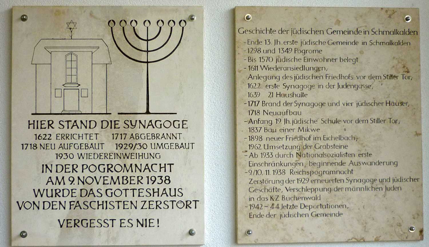
Among the Jews*Jewesses who were allowed to settle in Schmalkalden in 1611 with the permission of Landgrave Moritz of Hesse-Kassel was Isaak Schmuel. At his instigation, a synagogue, a small low building, was erected in a courtyard in the corner of Judengasse in 1622 and ceremonially opened in the same year. In 1639 there were 21 Jewish families living in the town, by 1666 the number had decreased again to eleven families with 23 persons. Around this time, in addition to the synagogue, mikvah and school, they also used their own cemetery at the Stiller Tor.
In the night of June 6 to 7, 1717, the synagogue fell victim to a city fire, along with four other Jewish homes in Judengasse and other houses. The synagogue was rebuilt in the following year as an unadorned and high building without windows on the street side and with an entrance on the courtyard side. In this form it existed for another 200 years.
When in 1929/30 the Judengasse was redeveloped for traffic, the old synagogue was demolished. The new building, designed by the architect Walter Peter, was kept simple. The simple building looked like a residential house with a representative entrance front. The inauguration took place in 1930.
During the pogrom on November 9, 1938, the barely ten-year-old building was severely damaged; afterwards, the remains were blown up. The Jewish inhabitants* of the city had themselves cleared their place of worship and watched the burning of the ritual objects in the market square. A two-story residential building was erected on the cleared lot. Since 1989, a memorial plaque commemorates the former synagogue at this location; later, an information board was added.
Altmarkt 12
98574 Schmalkalden
Germany
At the beginning of the 19th century, the professional structure of the Jews*Jewesses of Schmalkalden changed: They now also practiced crafts such as saddlers, tailors and linen weavers. Especially after the dismantling of all legal restrictions from 1871, more Jewish families settled in Schmalkalden; they were not insignificant for the economic development of Schmalkalden; thus Jews*Jewesses also founded small industrial companies here. However, if there were still 24 Jewish businessmen in Schmalkalden in 1930, all businesses were "Aryanized" or liquidated during the Nazi era by the end of 1938.
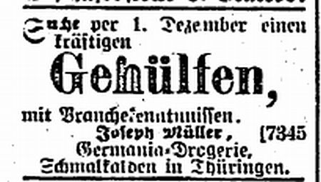
Josef Müller (May 30, 1862-November 21, 1925) ran the Germania drugstore in Schmalkalden, a "drugstore, chemical and paint store" in a prime location on the Altmarkt. He was head of the Jewish community, married Clara Mandel and had five children: Hedwig (married Paul Herbert Marcks), Alfred, Robert, Willi and Ernst. After Josef's death, his sons ran the drugstore. Part of the family left Germany before 1938. In the November 1938 pogrom, supporters of the Nazi regime destroyed the store and Willy, who now ran the drugstore alone, also emigrated. The drugstore was taken over by Walter Vollmer and the entire building was destroyed by an American bomb on February 6, 1945 during the second air raid on Schmalkalden.
Ernst and his family fled to Greece via Nuremberg and emigrated from there to New York City. Ernst ran successful medical practices in Greece and New York City. He died in 1953. Robert and his family fled to Trinidad and on to Chicago. Robert died in 1956, and Willi Müller did not marry. He fled to Shanghai and emigrated to Houston, Texas after the war. He was a concert pianist and died in Houston in 1968. Hedwig emigrated with her husband and children Lilly, Heinz and Helga to Shanghai and from there to Houston after the war ended. Paul Marcks died in Shanghai in 1941, Hedwig in Houston in 1962.
Today (2019) there is a construction gap on the site of the former drugstore building.
Auer Gasse 9
98574 Schmalkalden
Germany
Ludwig Pappenheim was an editor and local politician. He was born March 17, 1887 in Eschwege into a merchant family. He completed a merchant apprenticeship in Hamburg and worked in his father's business until 1913. While still an apprentice - symbolically on May 1 - he joined the SPD in 1905. He was entrusted with the reorganization of party work in Schmalkalden, which was still Hesse at the time. As a soldier in World War I, he became a pacifist. Already at the front he wrote with comrades numerous leaflets against the war.
With his inheritance, Pappenheim founded the newspaper "Volksstimme" in Auergasse 9 and worked there as an editor since 1919. From 1920, he sat as a deputy of the SPD in the provincial parliament of the province of Hesse-Nassau and held numerous offices and functions in SPD committees. He was committed to improving the conditions of the working class, to public health, youth work and the construction of cooperative housing: He was considered an advocate for the poor and was popular among the working class.
With his wife Frieda and four children he lived in his own house Sybillenburg 6. Because of his political ideals he was repeatedly imprisoned. During the war he had to answer to a field court, and in 1919 he was arrested in connection with workers' unrest. In 1923 and 1924 he was imprisoned in Suhl prison for unknown reasons. On March 25, 1933 - two days after the enactment of the National Socialist "Enabling Act" - the declared opponent of the war was arrested (unjustly) on the basis of an anonymous denunciation for alleged possession of a cache of weapons. Imprisoned in the concentration camp Neusustrum in Emsland, he was shot there on 04 January 1934 allegedly "on the run".
After 1945, the village of Kleinschmalkalden was renamed "Pappenheim", and in 1990 the designation was reversed. Seven years later, a square there with a memorial stone dedicated to him received his name.
Weidebrunner Gasse 28
98574 Schmalkalden
Germany
In 1881, the banking house "Wachenfeld & Gumprich" was founded in Schmalkalden. The shareholder and banker Friedrich Jacob Gumprich, who had been born in Neustadt an der Haard in 1857, belonged to the Jewish community. The Schmalkalden banking house had seven branches at times, and four in the end, and employed an average of 30 people, including apprentices. Friedrich Jacob Gumprich supported and promoted industry and crafts as well as the technical school in Schmalkalden and was a member of the "Gesellschaft zur Bewaldung der Queste".
In 1893, he married Irene Gunz (1872-1944), a native of Augsburg. The couple had four children. Irene Gumprich was very involved in social activities. She founded the Irene Gumprich Foundation for war victims of World War 1 and donated funds for infant and youth welfare.
When Friedrich Jacob Gumprich died in 1922, the share in the bank remained in family ownership. In 1930, the bank was converted into a limited partnership (KG). The partners were the heirs of Else Wachenfeld and the Gumprich family.
The bank remained in the hands of the Gumprich family.
On the night of the pogroms on November 9, 1938, the Bankhaus building was subjected to attacks by National Socialist militants. In the same year, 1938, the Jewish shareholders* were forced out of the bank. Max Gumprich, along with many other Jewish citizens, was deported to the Buchenwald concentration camp. After agreeing to the expropriation of his assets, he and his wife were able to emigrate to the United States via Cuba.
Irene Gumprich, on the other hand, remained in Schmalkalden. In March 1943, she was taken from her apartment as a 70-year-old woman and brought to the Gestapo in Weimar. On April 19, 1943, she was deported from Berlin to Theresienstadt, where she died. On February 29, 1944, she was cremated.
The former bank "Wachenfeld & Gumprich" was called "Wachenfeld's heirs & von Dadelsen" from 1938. After the war, the reopening under this name succeeded at the beginning of November 1945. In 1949, however, private banking transactions were banned. The still existing private banks became the property of the state of Thuringia.
Eichelbach 23
98574 Schmalkalden
Germany
The "new" Jewish cemetery was established in 1898 next to the municipal cemetery. It has been maintained again since 1988; an iron entrance gate features a Star of David. The site is divided into two sections. To the right of the entrance are the gravesites established after 1898. The 48 graves, including double graves, are arranged in four rows on both sides of a path.
The graves are made of black granite, have a stone grave border, German inscriptions and are kept simple. The statutes of the Jewish community of 1882 stipulated that burial was also permitted to former Jews*Jewesses who had left the community.
On the grounds to the left of the entrance are gravestones that date from the old and first cemetery. This had been laid out in 1611 directly in front of the east gate of the city (Stiller Tor) and used until 1895. Next to it stood the Jewish schoolhouse with a mikvah. A necessary extension of the old cemetery failed due to the refusal of the city administration and the objections of neighbors. The Jewish community therefore acquired a plot of land in Eichelbach, in the immediate vicinity of the municipal cemetery, which was also newly established.
In 1960, the old cemetery site was leveled in the course of the city expansion and the then still existing, about 100 gravestones moved to the new cemetery. Among them is the tomb of the well-known Talmudist Rabbi Chaim Schweich. A memorial stone erected in 1962 refers to this transfer.
The tombs were erected in seven rows to the left behind the memorial stone on a slight slope. The oldest legible inscription dates from 1652. The standing stones of sandstone are designed in the majority traditional: Rounded at the upper edge and decorated with palmette, blossom and tendril motifs, they have partly extensive Hebrew inscriptions and are provided with the typical symbols jug, blessing hands or palm branch.
"features": [
{
"type": "Feature",
"properties": {},
"geometry": {
"coordinates": [
[
10.455005,
50.720562
],
[
10.455007,
50.720719
],
[
10.455047,
50.720848
],
[
10.455268,
50.72116
],
[
10.455304,
50.721362
],
[
10.455281,
50.721708
],
[
10.455244,
50.721769
],
[
10.454463,
50.722035
],
[
10.454141,
50.722131
],
[
10.453898,
50.722177
],
[
10.453661,
50.722173
],
[
10.453472,
50.722112
],
[
10.453229,
50.721973
],
[
10.453147,
50.721916
],
[
10.452671,
50.721558
],
[
10.452635,
50.721571
],
[
10.452391,
50.721708
],
[
10.45213,
50.721562
],
[
10.452024,
50.721527
],
[
10.451884,
50.721498
],
[
10.451583,
50.7214
],
[
10.451213,
50.721308
],
[
10.450959,
50.721016
],
[
10.450134,
50.720795
],
[
10.450078,
50.720784
],
[
10.449833,
50.720749
],
[
10.449764,
50.720932
],
[
10.44948,
50.721478
],
[
10.449585,
50.721599
],
[
10.449366,
50.721782
],
[
10.44941,
50.721812
],
[
10.449513,
50.721872
],
[
10.449735,
50.721954
],
[
10.44988,
50.72202
],
[
10.449995,
50.722083
],
[
10.450106,
50.722193
],
[
10.450122,
50.72225
],
[
10.45008,
50.722376
],
[
10.450012,
50.722527
],
[
10.449954,
50.72286
],
[
10.450048,
50.7234
],
[
10.450083,
50.723509
],
[
10.450145,
50.723572
],
[
10.45046,
50.723701
],
[
10.450581,
50.723766
],
[
10.451236,
50.724229
],
[
10.451613,
50.724447
],
[
10.451742,
50.72451
],
[
10.451814,
50.724538
],
[
10.451908,
50.724555
],
[
10.452523,
50.724541
],
[
10.452471,
50.724684
],
[
10.452675,
50.724984
]
],
"type": "LineString"
},
"id": "64c89a96ce259add2113626567dd788f"
},
{
"type": "Feature",
"properties": {
"accuracy": "point",
"place_name": "Eichelbach 23, 98574 Schmalkalden, Germany"
},
"geometry": {
"coordinates": [
10.438849,
50.724275
],
"type": "Point"
},
"id": "address.1641297698388604"
},
{
"type": "Feature",
"properties": {
"accuracy": "point",
"place_name": "Hoffnung 38, 98574 Schmalkalden, Germany"
},
"geometry": {
"coordinates": [
10.453862,
50.722237
],
"type": "Point"
},
"id": "address.1893509571381150"
},
{
"type": "Feature",
"properties": {
"accuracy": "point",
"place_name": "Näherstiller Straße 3, 98574 Schmalkalden, Germany"
},
"geometry": {
"coordinates": [
10.458786,
50.719897
],
"type": "Point"
},
"id": "address.2528921910403962"
},
{
"type": "Feature",
"properties": {
"accuracy": "point",
"place_name": "Auer Gasse 9, 98574 Schmalkalden, Germany"
},
"geometry": {
"coordinates": [
10.4502,
50.72076
],
"type": "Point"
},
"id": "address.2665599312835558"
},
{
"type": "Feature",
"properties": {
"accuracy": "interpolated",
"place_name": "Altmarkt 12, 98574 Schmalkalden, Germany"
},
"geometry": {
"coordinates": [
10.451336,
50.721337
],
"type": "Point"
},
"id": "address.3664192415092008"
},
{
"type": "Feature",
"properties": {
"accuracy": "point",
"place_name": "Weidebrunner Gasse 28, 98574 Schmalkalden, Germany"
},
"geometry": {
"coordinates": [
10.452754,
50.724949
],
"type": "Point"
},
"id": "address.4276258586972448"
},
{
"type": "Feature",
"properties": {
"accuracy": "interpolated",
"place_name": "Judengasse 35, 98574 Schmalkalden, Germany"
},
"geometry": {
"coordinates": [
10.453195,
50.721952
],
"type": "Point"
},
"id": "address.5515005787716652"
},
{
"type": "Feature",
"properties": {},
"geometry": {
"coordinates": [
[
10.458751,
50.719858
],
[
10.458368,
50.719972
],
[
10.457412,
50.720245
],
[
10.456794,
50.720411
],
[
10.456181,
50.72051
],
[
10.455793,
50.720568
],
[
10.455638,
50.720575
],
[
10.455356,
50.720577
],
[
10.455005,
50.720562
]
],
"type": "LineString"
},
"id": "d02215bbd77ed94ba15f3e885bfe879f"
}
],
"type": "FeatureCollection"
}
Add new comment